The Canal Pangalanes…for travelers
Overview
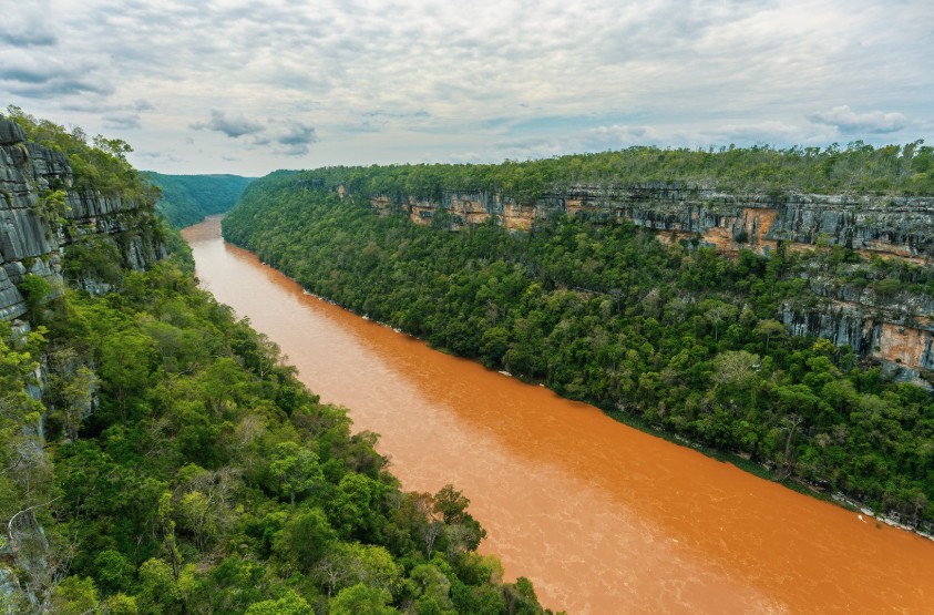
The Canal des Pangalanes stretches for hundreds of kilometers along Madagascar’s east coast, linking lakes, rivers, marshes and artificial waterways between the Indian Ocean and the mainland. Parts of it are natural. Other sections were connected during the French colonial period to create an inland navigation route safer than the open ocean, where heavy surf and unstable weather made coastal travel dangerous.
Construction and canal connections expanded mainly between the late 19th and early 20th century. The objective was practical more than ambitious tourism. Coffee, cloves, vanilla, timber, rice and other goods moved slowly by boat between isolated villages and ports inaccessible by road.
Even today, large sections of the canal remain active for local transport. Cargo pirogues, dugout canoes, small passenger boats and fishermen still use the waterways daily. In some places the canal feels busy. In others, vegetation almost closes over the water.
Traveling through the Canal des Pangalanes is less about beaches and more about atmosphere. Humid forests, villages reachable only by water, children paddling small canoes to school, wood smoke rising above the trees late afternoon. The further south you go, the wilder and less organized everything becomes.
Northern Section — Tamatave / Toamasina to Vatomandry
The northern part of the Canal des Pangalanes is the easiest and most visited section. It combines tropical lakes, forest reserves and relatively comfortable navigation.
Most travelers begin from Tamatave / Toamasina or directly from Manambato. The classic boat route toward Palmarium Reserve takes roughly 4 hours depending on lake conditions and weather. Large expanses of water alternate with narrow canals lined by ravinala, pandanus and fishing villages.
The shorter crossing between Palmarium Reserve and Manambato usually takes around 2 hours and remains one of the calmest sections of the canal.
Further south, navigation between Manambato and Vatomandry takes roughly 8 hours by boat through quieter villages, marshes and increasingly isolated sections of the waterway.
This northern region remains ideal for travelers wanting a first experience of the Pangalanes without committing to full expedition-style travel.
Middle Section — Vatomandry to Mananjary
South of Vatomandry, the canal changes atmosphere. Boat traffic decreases, villages become more isolated and long sections feel almost disconnected from the rest of Madagascar.
The route between Vatomandry and Mahanoro takes around 8 hours by boat. Narrow canals alternate with larger lakes exposed to wind and rain. Cargo pirogues still transport cloves, coffee, charcoal and lychees between villages.
From Mahanoro to Nosy Varika, navigation usually requires around 5 hours. Tropical vegetation becomes denser and humidity heavier, especially after rainfall when morning mist hangs low above the water.
The section between Nosy Varika and Mananjary takes roughly 7 hours and remains one of the most atmospheric parts of the canal. Fewer visitors reach this area and some villages remain accessible only by water.
This central section of the Canal des Pangalanes probably offers the strongest feeling of slow travel through Madagascar’s east coast.
Southern Section — Mananjary to Manakara
The southern section between Mananjary and Manakara remains the wildest and least developed part of the entire Canal des Pangalanes.
There are no regular tourist boats here and infrastructure becomes extremely limited. Large sections pass through isolated forest, marshes and abandoned waterways where vegetation slowly reclaims parts of the canal.
This route is usually explored either by kayak over roughly 5 days or by traditional canoe / pirogue expeditions lasting around 3 days depending on conditions and pace.
Travel here feels completely different from the northern canal. Villages become rare. Nights are humid and noisy with insects and frogs. Clothing rarely dries fully. Some evenings the only light comes from cooking fires reflected on dark water beside the camps.
This is one of the most remote slow-travel experiences remaining in Madagascar.
Map
When to Go
May to November is generally the best period to explore the Canal des Pangalanes. Rain becomes less intense, lakes are usually calmer and long boat journeys become easier and more reliable.
Between July and September, temperatures are slightly cooler and humidity becomes more manageable, especially for multi-day expeditions further south.
The east coast of Madagascar remains humid year-round though. Short tropical showers can happen during any season and morning mist over the canal is common, especially after rain.
From December to March, cyclones and heavy tropical rains can seriously affect navigation conditions. Some sections become difficult or impossible depending on weather, water levels and wind on the larger lakes.
The southern section between Mananjary and Manakara is usually best attempted during the drier months when camping conditions improve and canal currents remain more stable.
Activities
- Multi-day boat expeditions along the Canal des Pangalanes
- Visiting Palmarium Reserve
- Observing lemurs and the aye-aye
- Traveling by traditional pirogue
- Multi-day kayak expeditions between Mananjary and Manakara
- Visiting isolated east coast villages
- Birdwatching in lakes, marshes and wetlands
- Photography of daily life along the canal
- Exploring humid tropical vegetation
- Fishing excursions with local communities
- Discovering remote lakes connected to the canal system
- Camping along wild canal sections
- Watching cargo pirogues navigate between villages
- Exploring traditional east coast culture
- Adventure canoe expeditions through remote waterways
You may also like